
Make a donation
Gear up for your next adventure:
As an Amazon Associate, this site earns from qualifying purchases at no extra cost to you.
Mera Peak topographic map
Click on the map to display elevation.
Make a donation
Gear up for your next adventure:
As an Amazon Associate, this site earns from qualifying purchases at no extra cost to you.
Mera Peak
In September 2017, Hari Budha Magar summited Mera Peak, becoming the first double above-knee amputee to climb a mountain over 6,000m in altitude.
Make a donation
Gear up for your next adventure:
As an Amazon Associate, this site earns from qualifying purchases at no extra cost to you.
About this map
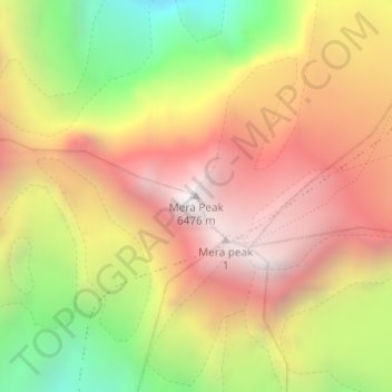
Name: Mera Peak topographic map, elevation, terrain.
Location: Mera Peak, Mahakulung, Solukhumbu, Koshi Province, Nepal (27.70979 86.86861 27.70989 86.86871)
Average elevation: 5,709 m
Minimum elevation: 4,779 m
Maximum elevation: 6,450 m
Make a donation
Gear up for your next adventure:
As an Amazon Associate, this site earns from qualifying purchases at no extra cost to you.
Other topographic maps
Click on a map to view its topography, its elevation and its terrain.
Make a donation
Gear up for your next adventure:
As an Amazon Associate, this site earns from qualifying purchases at no extra cost to you.