Geolocate

Govilon topographic map

Click on the map to display elevation.

About this map

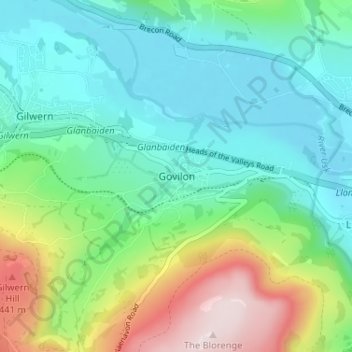
Name: Govilon topographic map, elevation, terrain.

Location: Govilon, Monmouthshire, Wales, NP7 9RB, United Kingdom (51.79874 -3.08665 51.83874 -3.04665)

Average elevation: 186 m

Minimum elevation: 44 m

Maximum elevation: 554 m

Monmouthshire trails, hiking, mountain biking, running and outdoor activities

Other topographic maps

Click on a map to view its topography, its elevation and its terrain.

Wye Valley

United Kingdom > Wales > Monmouthshire

Average elevation: 167 m

Penallt

United Kingdom > Wales > Monmouthshire

Average elevation: 174 m

Crucorney

United Kingdom > Wales > Monmouthshire

Average elevation: 297 m

Blorenge

United Kingdom > Wales > Monmouthshire > Govilon

Average elevation: 394 m

River Monnow

United Kingdom > Wales > Monmouthshire

Average elevation: 172 m

Llanbadoc

United Kingdom > Wales > Monmouthshire

Average elevation: 78 m

Raglan Castle

United Kingdom > Wales > Monmouthshire > Raglan

Average elevation: 59 m

River Monnow

United Kingdom > Wales > Monmouthshire

Average elevation: 172 m

Gear up for your next adventure:

🎒Hiking Child Carriers - Explore the outdoors with the whole family safely
🥾Men's Waterproof Hiking Boots - Durable footwear with deep lugs for muddy and rocky UK terrains
🥾Walking Shoes - Lightweight walking shoes for countryside and coastal paths
🧊Insulated Flasks - Keeps drinks hot or cold during hikes
❄️Walking Crampons - Added traction for icy slopes and winter peak bagging

As an Amazon Associate, this site earns from qualifying purchases at no extra cost to you.