
Make a donation
Gear up for your next adventure:
As an Amazon Associate, this site earns from qualifying purchases at no extra cost to you.
Druogno topographic map
Click on the map to display elevation.
Make a donation
Gear up for your next adventure:
As an Amazon Associate, this site earns from qualifying purchases at no extra cost to you.
About this map
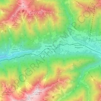
Name: Druogno topographic map, elevation, terrain.
Location: Druogno, Verbano-Cusio-Ossola, Piedmont, Italy (46.09365 8.37495 46.16980 8.44565)
Average elevation: 1,294 m
Minimum elevation: 616 m
Maximum elevation: 2,259 m
Make a donation
Gear up for your next adventure:
As an Amazon Associate, this site earns from qualifying purchases at no extra cost to you.
Other topographic maps
Click on a map to view its topography, its elevation and its terrain.
Ghiacciaio del Belvedere
Italy > Piedmont > Verbano-Cusio-Ossola > Macugnaga
Average elevation: 2,211 m
Make a donation
Gear up for your next adventure:
As an Amazon Associate, this site earns from qualifying purchases at no extra cost to you.
Make a donation
Gear up for your next adventure:
As an Amazon Associate, this site earns from qualifying purchases at no extra cost to you.
Alpe Cheggio
Italy > Piedmont > Verbano-Cusio-Ossola > Antrona Schieranco > Alpe Cheggio
Average elevation: 1,830 m