
Make a donation
Gear up for your next adventure:
As an Amazon Associate, this site earns from qualifying purchases at no extra cost to you.
Valsad topographic map
Click on the map to display elevation.
Make a donation
Gear up for your next adventure:
As an Amazon Associate, this site earns from qualifying purchases at no extra cost to you.
Valsad
Valsad is located at 20°38′N 72°56′E / 20.63°N 72.93°E / 20.63; 72.93. It has an average elevation of 13 metres (42 feet). The old city is about 4 km inland from the Arabian Sea.
Make a donation
Gear up for your next adventure:
As an Amazon Associate, this site earns from qualifying purchases at no extra cost to you.
About this map
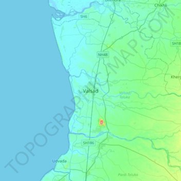
Name: Valsad topographic map, elevation, terrain.
Location: Valsad, Valsad Taluka, Valsad, Gujarat, 395125, India (20.44678 72.76729 20.76678 73.08729)
Average elevation: 16 m
Minimum elevation: -3 m
Maximum elevation: 154 m
Make a donation
Gear up for your next adventure:
As an Amazon Associate, this site earns from qualifying purchases at no extra cost to you.