
Thank you for supporting this site ❤️
Make a donation
Make a donation
Gear up for your next adventure:
As an Amazon Associate, this site earns from qualifying purchases at no extra cost to you.
Gablenz - Jabłońc topographic map
Click on the map to display elevation.
Thank you for supporting this site ❤️
Make a donation
Make a donation
Gear up for your next adventure:
As an Amazon Associate, this site earns from qualifying purchases at no extra cost to you.
About this map
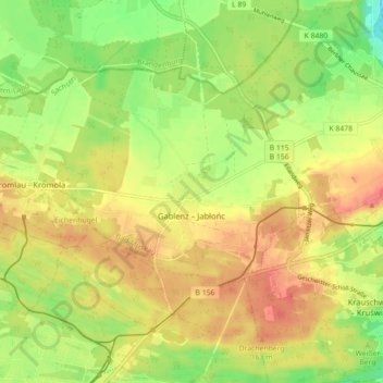
Name: Gablenz - Jabłońc topographic map, elevation, terrain.
Location: Gablenz - Jabłońc, Bad Muskau, Görlitz, Saxony, 02953, Germany (51.51888 14.60318 51.55474 14.69160)
Average elevation: 137 m
Minimum elevation: 104 m
Maximum elevation: 165 m
Thank you for supporting this site ❤️
Make a donation
Make a donation
Gear up for your next adventure:
As an Amazon Associate, this site earns from qualifying purchases at no extra cost to you.