Geolocate

Orderville topographic map

Click on the map to display elevation.

About this map

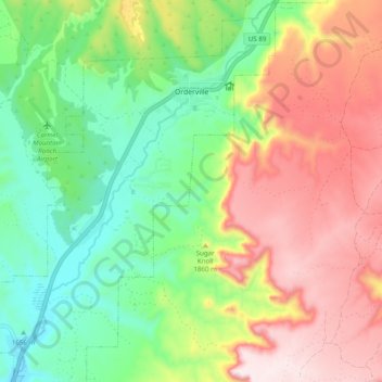
Name: Orderville topographic map, elevation, terrain.

Location: Orderville, Kane County, Utah, 84755, United States (37.21615 -112.69281 37.29414 -112.61672)

Average elevation: 1,828 m

Minimum elevation: 1,576 m

Maximum elevation: 2,161 m

Other topographic maps

Click on a map to view its topography, its elevation and its terrain.

Duck Creek Village

United States > Utah > Kane County

Average elevation: 2,608 m

Bald Knoll

United States > Utah > Kane County

Average elevation: 2,024 m

Millet Point

United States > Utah > Kane County

Average elevation: 2,107 m

Navajo Lake Lodge

United States > Utah > Kane County

Average elevation: 2,841 m

Coyote Natural Bridge

United States > Utah > Kane County

Average elevation: 1,361 m

Rainbow Point

United States > Utah > Kane County

Average elevation: 2,578 m

Duck Creek Village

United States > Utah > Kane County

Average elevation: 2,608 m

Gear up for your next adventure:

🔋Lithium AA Batteries - Long-lasting power that performs well in cold mountain weather
Insulated Travel Mugs - Keep drinks hot while surveying the landscape from a summit
🧣Fleece Neck Warmers - Extra insulation for winter topographic surveys
🦟Anti-Midge & Tick Repellent - Vital for hiking in the Scottish Highlands during summer
📸Action Camera Chest Mounts - Record your ascent following topographic paths hands-free

As an Amazon Associate, this site earns from qualifying purchases at no extra cost to you.