
Βλαχόπουλο topographic map
Interactive map
Click on the map to display elevation.
About this map
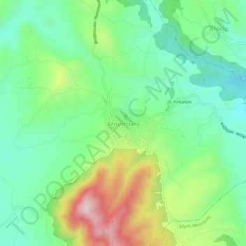
Name: Βλαχόπουλο topographic map, elevation, terrain.
Average elevation: 430 m
Minimum elevation: 291 m
Maximum elevation: 711 m
Other topographic maps
Click on a map to view its topography, its elevation and its terrain.
Ριζόμυλος
Greece > Peloponnese, Western Greece and the Ionian > Messenia Regional Unit
Average elevation: 63 m
Mandra
Greece > Peloponnese, Western Greece and the Ionian > Messenia Regional Unit
Average elevation: 239 m
Αλαγονία
Greece > Peloponnese, Western Greece and the Ionian > Messenia Regional Unit > Municipality of Kalamata
Average elevation: 900 m
Stoupa
Greece > Peloponnese, Western Greece and the Ionian > Messenia Regional Unit > Municipal Unit of Lefktro
Average elevation: 63 m
Voreio
Greece > Peloponnese, Western Greece and the Ionian > Messenia Regional Unit > Municipal Unit of Avia
Average elevation: 668 m
Palace of Nestor
Greece > Peloponnese, Western Greece and the Ionian > Messenia Regional Unit > Chora > Pisaski
Average elevation: 146 m
Diavolitsi
Greece > Peloponnese, Western Greece and the Ionian > Messenia Regional Unit
Average elevation: 157 m
Municipality of Pylos and Nestor
Greece > Peloponnese, Western Greece and the Ionian > Messenia Regional Unit
Average elevation: 101 m
Καλαμάκι
Greece > Peloponnese, Western Greece and the Ionian > Messenia Regional Unit
Average elevation: 344 m
Exochori
Greece > Peloponnese, Western Greece and the Ionian > Messenia Regional Unit > Municipal Unit of Lefktro
Average elevation: 501 m
Pylos
Greece > Peloponnese, Western Greece and the Ionian > Messenia Regional Unit
The erection of this fort led to one of the most memorable events in the Peloponnesian War. Thucydides has given a minute account of the topography of the district, which, though clear and consistent with itself, does not coincide, in all points, with the existing locality, Thucydides describes the harbour, of…
Average elevation: 79 m
Κυπαρισσία
Greece > Peloponnese, Western Greece and the Ionian > Messenia Regional Unit > Kyparissia Municipal Unit > Κυπαρισσία
Average elevation: 152 m
Kardamyli
Greece > Peloponnese, Western Greece and the Ionian > Messenia Regional Unit > Municipal Unit of Lefktro
Average elevation: 96 m
Municipality of Kalamata
Greece > Peloponnese, Western Greece and the Ionian > Messenia Regional Unit
Average elevation: 490 m