Geolocate

Lepșa topographic map

Interactive map

Click on the map to display elevation.

About this map

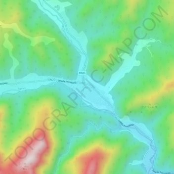
Name: Lepșa topographic map, elevation, terrain.

Location: Lepșa, Tulnici, Vrancea, 627369, Romania (45.93062 26.55522 45.97062 26.59522)

Average elevation: 747 m

Minimum elevation: 545 m

Maximum elevation: 1,222 m

Other topographic maps

Click on a map to view its topography, its elevation and its terrain.

Rucăreni

Romania > Vrancea

Average elevation: 576 m

Coza

Romania > Vrancea

Average elevation: 535 m

Poiana Cristei

Romania > Vrancea

Average elevation: 348 m

Odobești

Romania > Vrancea

Average elevation: 220 m

Adjud

Romania > Vrancea

Adjud is situated on a plain and is surrounded by hills up to a height of 400 meters at the foot of the southern Carpathians. The average altitude of the town is 100 m above sea level. The surrounding land is favorable for agriculture.

Average elevation: 138 m

Tulnici

Romania > Vrancea

Average elevation: 683 m

Focșani

Romania > Vrancea

Average elevation: 59 m

Adjud

Romania > Vrancea > Adjud

Average elevation: 110 m