
Aleosan topographic map
Click on the map to display elevation.
About this map
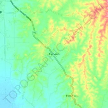
Name: Aleosan topographic map, elevation, terrain.
Location: Aleosan, North Cotabato, Soccsksargen, 9415, Philippines (7.11858 124.53740 7.19858 124.61740)
Average elevation: 44 m
Minimum elevation: 5 m
Maximum elevation: 125 m
Other topographic maps
Click on a map to view its topography, its elevation and its terrain.
Magpet
Rice production in Magpet is only 1.16% or 1,028 hectares of the total land area with another 1.50% or 1,115 hectares as potential area due to its land topography, which is mostly hilly or mountainous.
Average elevation: 597 m
Kabacan
The landscape is characterized by almost regular landscape of flat terrain. The high mountains and rolling hills leaping close to the river plus the narrow plains have varied topographical features. Other features are moderately sloping and strongly sloping.
Average elevation: 95 m