
La Brévine topographic map
Interactive map
Click on the map to display elevation.
La Brévine
The municipality was located in the district of Le Locle until the district level was eliminated on 1 January 2018. It is near the French border. It consists of the village of La Brévine (elevation 1,046 m or 3,432 ft) and the hamlets of Le Brouillet, Bémont, Les Taillères and La Châtagne, as well as scattered farmhouses.
About this map
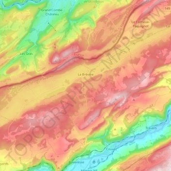
Name: La Brévine topographic map, elevation, terrain.
Location: La Brévine, Neuchâtel, 2406, Switzerland (46.94382 6.48576 47.00011 6.66672)
Average elevation: 1,042 m
Minimum elevation: 723 m
Maximum elevation: 1,322 m
Other topographic maps
Click on a map to view its topography, its elevation and its terrain.
La Ronde
Switzerland > Neuchâtel > Bernese Jura administrative district > La Chaux-de-Fonds
Average elevation: 807 m