Geolocate

Ashtabula topographic map

Click on the map to display elevation.

About this map
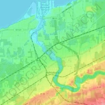
Name: Ashtabula topographic map, elevation, terrain.

Location: Ashtabula, Ashtabula County, Ohio, 44004, United States (41.84358 -80.83720 41.91178 -80.76721)

Average elevation: 202 m

Minimum elevation: 171 m

Maximum elevation: 263 m

Other topographic maps

Click on a map to view its topography, its elevation and its terrain.
Pierpont

United States > Ohio > Ashtabula County

Average elevation: 305 m

Chapel

United States > Ohio > Ashtabula County

Average elevation: 258 m

Phelps Creek

United States > Ohio > Ashtabula County

Average elevation: 326 m

Pierpont

United States > Ohio > Ashtabula County

Average elevation: 305 m

Gear up for your next adventure:

🦶Anti-Blister Balms - Protect your feet before long topographic expeditions
📚UK Hiking Guidebooks - Detailed route descriptions for the Lake District, Peaks, and Highlands
🥾Hiking Boot Waterproofing Wax - Maintain the lifespan of your leather trekking boots
🦯Walking Poles - Supportive poles for long-distance walking
🔋Lithium AA Batteries - Long-lasting power that performs well in cold mountain weather

As an Amazon Associate, this site earns from qualifying purchases at no extra cost to you.