Geolocate

Kyle topographic map

Click on the map to display elevation.

About this map
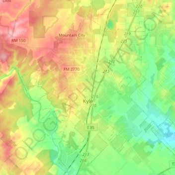
Name: Kyle topographic map, elevation, terrain.

Location: Kyle, Hays County, Texas, 78640, United States (29.94277 -97.97470 30.05550 -97.82502)

Average elevation: 221 m

Minimum elevation: 168 m

Maximum elevation: 290 m

Other topographic maps

Click on a map to view its topography, its elevation and its terrain.

Hays City

United States > Texas > Hays County

Average elevation: 291 m

Driftwood

United States > Texas > Hays County

Average elevation: 319 m

Henly

United States > Texas > Hays County

Average elevation: 405 m

Lone Woman Mountain

United States > Texas > Hays County

Average elevation: 381 m

Henly

United States > Texas > Hays County

Average elevation: 405 m

Yell

United States > Texas > Hays County

Average elevation: 403 m

Gear up for your next adventure:

🧼Camping Hygiene Kits - Compact hygiene essentials for outdoor stays
🧦Hiking Socks - Breathable socks designed to prevent blisters on long walks
🔦Keychain LED Torches - Emergency backup light for finding gear in your pack
🥾Walking Shoes - Lightweight walking shoes for countryside and coastal paths
👟Women's Trail Running Shoes - Agile footwear for fell running and technical trails

As an Amazon Associate, this site earns from qualifying purchases at no extra cost to you.