
Thank you for supporting this site ❤️
Make a donation
Make a donation
Gear up for your next adventure:
As an Amazon Associate, this site earns from qualifying purchases at no extra cost to you.
Sairang topographic map
Click on the map to display elevation.
Thank you for supporting this site ❤️
Make a donation
Make a donation
Gear up for your next adventure:
As an Amazon Associate, this site earns from qualifying purchases at no extra cost to you.
Sairang
Sairang is located at 23°48′N 92°40′E / 23.8°N 92.67°E / 23.8; 92.67. It has an average elevation of 210 metres (688 feet).
Thank you for supporting this site ❤️
Make a donation
Make a donation
Gear up for your next adventure:
As an Amazon Associate, this site earns from qualifying purchases at no extra cost to you.
About this map
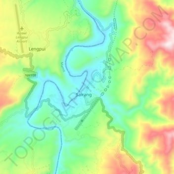
Name: Sairang topographic map, elevation, terrain.
Location: Sairang, Tlangnuam, Aizwal, Mizoram, 796410, India (23.77370 92.61385 23.85370 92.69385)
Average elevation: 334 m
Minimum elevation: 57 m
Maximum elevation: 833 m
Thank you for supporting this site ❤️
Make a donation
Make a donation
Gear up for your next adventure:
As an Amazon Associate, this site earns from qualifying purchases at no extra cost to you.