
Thank you for supporting this site ❤️
Make a donation
Make a donation
Gear up for your next adventure:
As an Amazon Associate, this site earns from qualifying purchases at no extra cost to you.
Chinchero topographic map
Click on the map to display elevation.
Thank you for supporting this site ❤️
Make a donation
Make a donation
Gear up for your next adventure:
As an Amazon Associate, this site earns from qualifying purchases at no extra cost to you.
About this map
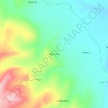
Name: Chinchero topographic map, elevation, terrain.
Location: Chinchero, Caylloma, Province of Caylloma, Arequipa, Peru (-14.95569 -71.88845 -14.91569 -71.84845)
Average elevation: 4,536 m
Minimum elevation: 4,413 m
Maximum elevation: 4,797 m
Thank you for supporting this site ❤️
Make a donation
Make a donation
Gear up for your next adventure:
As an Amazon Associate, this site earns from qualifying purchases at no extra cost to you.