Geolocate

Val-d'Or topographic map

Click on the map to display elevation.

Val-d'Or

Val-d’Or is situated on the Canadian Shield at an elevation of 1100 feet (330m) above sea level. Although its name refers to a valley (“Val”), the city is actually situated on a vast, slightly undulating plain.

Wikipedia (CC-BY-SA 3.0)

About this map

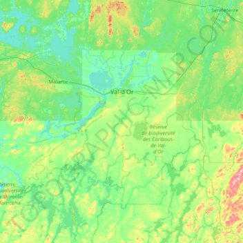
Name: Val-d'Or topographic map, elevation, terrain.

Location: Val-d'Or, La Vallée-de-l'Or, Abitibi-Témiscamingue, Quebec, Canada (47.70265 -78.22119 48.28753 -76.93323)

Average elevation: 331 m

Minimum elevation: 287 m

Maximum elevation: 551 m

Gear up for your next adventure:

❄️Walking Crampons - Added traction for icy slopes and winter peak bagging
🛰️Outdoor GPS Navigation - Navigation devices for remote and off-grid areas
🎒Backpack Rain Covers - Universal waterproof covers to protect your gear from downpours
🧷Tenacious Repair Tape - Instant fix for torn tents, jackets, or dry bags
🥾Women's Waterproof Hiking Boots - High-performance trekking boots designed for all-weather comfort

As an Amazon Associate, this site earns from qualifying purchases at no extra cost to you.