
Make a donation
Gear up for your next adventure:
As an Amazon Associate, this site earns from qualifying purchases at no extra cost to you.
Urmia topographic map
Click on the map to display elevation.
Make a donation
Gear up for your next adventure:
As an Amazon Associate, this site earns from qualifying purchases at no extra cost to you.
Urmia
The city lies at an altitude of 1,330 metres (4,360 ft) above sea level along the Shahar River on the Urmia Plain. Lake Urmia, one of the world's largest salt lakes, lies to the east of the city, and the border with Turkey lies to the west.
Make a donation
Gear up for your next adventure:
As an Amazon Associate, this site earns from qualifying purchases at no extra cost to you.
About this map
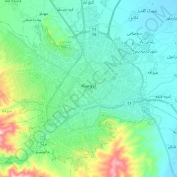
Name: Urmia topographic map, elevation, terrain.
Average elevation: 1,386 m
Minimum elevation: 1,293 m
Maximum elevation: 1,751 m
Make a donation
Gear up for your next adventure:
As an Amazon Associate, this site earns from qualifying purchases at no extra cost to you.
Other topographic maps
Click on a map to view its topography, its elevation and its terrain.
Karimabad
Iran > West Azerbaijan Province > Urumia County > دهستان نازلوشمالی
Average elevation: 1,327 m
Make a donation
Gear up for your next adventure:
As an Amazon Associate, this site earns from qualifying purchases at no extra cost to you.
Sinabad
Iran > West Azerbaijan Province > Urumia County > دهستان صومای جنوبی
Average elevation: 1,876 m
Khorramabad
Iran > West Azerbaijan Province > Urumia County > دهستان باراندوز
Average elevation: 1,379 m
Mamakan
Iran > West Azerbaijan Province > Urumia County > دهستان صومای شمالی
Average elevation: 1,883 m
Make a donation
Gear up for your next adventure:
As an Amazon Associate, this site earns from qualifying purchases at no extra cost to you.
Khorramabad
Iran > West Azerbaijan Province > Urumia County > دهستان باراندوز
Average elevation: 1,379 m
Guyj Ali Tappeh
Iran > West Azerbaijan Province > Urumia County > دهستان باش قلعه
Average elevation: 1,300 m
Darin Qaleh
Iran > West Azerbaijan Province > Urumia County > دهستان باراندوزچای جنوبی > Darin Qaleh
Average elevation: 1,625 m
Make a donation
Gear up for your next adventure:
As an Amazon Associate, this site earns from qualifying purchases at no extra cost to you.
Gol Pashin
Iran > West Azerbaijan Province > Urumia County > دهستان بکشلوچای > Gol Pashin
Average elevation: 1,299 m
Make a donation
Gear up for your next adventure:
As an Amazon Associate, this site earns from qualifying purchases at no extra cost to you.