
Hohegeiß topographic map
Interactive map
Click on the map to display elevation.
About this map
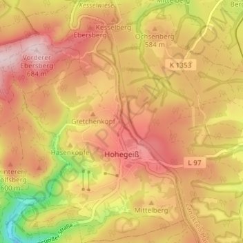
Name: Hohegeiß topographic map, elevation, terrain.
Location: Hohegeiß, Braunlage, Landkreis Goslar, Lower Saxony, Germany (51.65043 10.64002 51.68791 10.68399)
Average elevation: 568 m
Minimum elevation: 394 m
Maximum elevation: 679 m
Other topographic maps
Click on a map to view its topography, its elevation and its terrain.
Sankt Andreasberg
Germany > Lower Saxony > Landkreis Goslar > Braunlage
Sankt Andreasberg, Braunlage, Landkreis Goslar, Lower Saxony, Germany
Average elevation: 648 m