Geolocate

Malabag topographic map

Click on the map to display elevation.

About this map

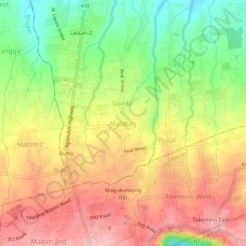
Name: Malabag topographic map, elevation, terrain.

Location: Malabag, Silang, Cavite, Calabarzon, 4118, Philippines (14.12355 120.94491 14.16355 120.98491)

Average elevation: 520 m

Minimum elevation: 435 m

Maximum elevation: 592 m

Other topographic maps

Click on a map to view its topography, its elevation and its terrain.

Silang - Santa Rosa River

Philippines > Cavite > Silang > Carmen

Average elevation: 117 m

Gear up for your next adventure:

🥾Women's Waterproof Hiking Boots - High-performance trekking boots designed for all-weather comfort
🧴Tick Removal Tools - Small, essential health tool for UK woodland and moorland
🧼Technical Clothing Wash - Special soap to clean and restore waterproof membranes
🩹Hiking First Aid Kits - Compact medical kits tailored for trail injuries and emergencies
🔥Emergency Fire Starters - Reliable ignition tools for survival situations in damp conditions

As an Amazon Associate, this site earns from qualifying purchases at no extra cost to you.