
Make a donation
Gear up for your next adventure:
As an Amazon Associate, this site earns from qualifying purchases at no extra cost to you.
Crescent City topographic map
Click on the map to display elevation.
Make a donation
Gear up for your next adventure:
As an Amazon Associate, this site earns from qualifying purchases at no extra cost to you.
About this map
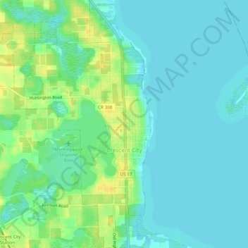
Name: Crescent City topographic map, elevation, terrain.
Location: Crescent City, Putnam County, Florida, United States (29.41384 -81.53612 29.45536 -81.50555)
Average elevation: 11 m
Minimum elevation: 3 m
Maximum elevation: 26 m
Make a donation
Gear up for your next adventure:
As an Amazon Associate, this site earns from qualifying purchases at no extra cost to you.
Other topographic maps
Click on a map to view its topography, its elevation and its terrain.
Georgetown
United States > Florida > Putnam County
Georgetown is located at 29°23′29″N 81°38′19″W / 29.391362°N 81.638689°W / 29.391362; -81.638689 (29.391362, -81.638689). Its elevation in 23 feet (7 m).
Average elevation: 6 m
Make a donation
Gear up for your next adventure:
As an Amazon Associate, this site earns from qualifying purchases at no extra cost to you.
Make a donation
Gear up for your next adventure:
As an Amazon Associate, this site earns from qualifying purchases at no extra cost to you.
San Mateo
United States > Florida > Putnam County
San Mateo is located at 29°36′25″N 81°35′06″W / 29.607°N 81.585°W / 29.607; -81.585, with an elevation of 72 feet (22 m).
Average elevation: 10 m
Make a donation
Gear up for your next adventure:
As an Amazon Associate, this site earns from qualifying purchases at no extra cost to you.
Georgetown
United States > Florida > Putnam County
Georgetown is located at 29°23′29″N 81°38′19″W / 29.391362°N 81.638689°W / 29.391362; -81.638689 (29.391362, -81.638689). Its elevation in 23 feet (7 m).
Average elevation: 6 m