Geolocate

Huntsville topographic map

Click on the map to display elevation.

About this map

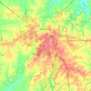
Name: Huntsville topographic map, elevation, terrain.

Location: Huntsville, Walker County, Texas, United States (30.60297 -95.64275 30.76895 -95.48761)

Average elevation: 108 m

Minimum elevation: 66 m

Maximum elevation: 155 m

Other topographic maps

Click on a map to view its topography, its elevation and its terrain.

Dodge

United States > Texas > Walker County

Average elevation: 115 m

Gear up for your next adventure:

🍲Portable Camping Stoves - Fast-boiling stoves for hot meals on remote topographic survey trips
👟Heavy Duty Boot Laces - Always carry a spare for your hiking footwear
👟Women's Trail Running Shoes - Agile footwear for fell running and technical trails
🐕Dog Hiking Gear - Equipment for hiking safely with dogs
🔋Lithium AA Batteries - Long-lasting power that performs well in cold mountain weather

As an Amazon Associate, this site earns from qualifying purchases at no extra cost to you.