Geolocate

Clarksburg topographic map

Click on the map to display elevation.

Clarksburg

Clarksburg is located at the junction of U.S. 50 and U.S. 19, two miles west of the junction of U.S. 50 with Interstate 79. The city lies at an elevation of 1,007 feet at the junction of Elk Creek and the West Fork River of the Monongahela River.

Wikipedia (CC-BY-SA 3.0)

About this map

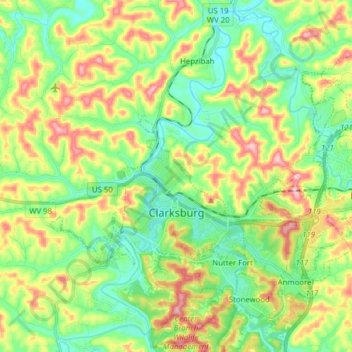
Name: Clarksburg topographic map, elevation, terrain.

Location: Clarksburg, Harrison County, West Virginia, United States (39.24993 -80.40078 39.33619 -80.24495)

Average elevation: 347 m

Minimum elevation: 275 m

Maximum elevation: 475 m

Other topographic maps

Click on a map to view its topography, its elevation and its terrain.

Goodhope

United States > West Virginia > Harrison County

Average elevation: 337 m

Wyatt

United States > West Virginia > Harrison County

Average elevation: 356 m

Gore

United States > West Virginia > Harrison County

Average elevation: 339 m

Haywood

United States > West Virginia > Harrison County

Average elevation: 328 m

Viropa

United States > West Virginia > Harrison County

Average elevation: 333 m

Gear up for your next adventure:

📦Compression Sacks - Reduce backpack volume efficiently
🐕Hiking Dog Harnesses - Rugged harnesses for taking your companion on mountain trails
🧵Survival Paracord - Multi-purpose cordage for emergency repairs and shelters
🥾Women's Waterproof Hiking Boots - High-performance trekking boots designed for all-weather comfort
🍱Food Containers - Reusable containers for outdoor meals

As an Amazon Associate, this site earns from qualifying purchases at no extra cost to you.