Geolocate

Noli topographic map

Click on the map to display elevation.

About this map

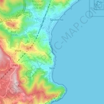
Name: Noli topographic map, elevation, terrain.

Location: Noli, Savona, Liguria, 17026, Italy (44.19021 8.37263 44.23579 8.42532)

Average elevation: 83 m

Minimum elevation: -1 m

Maximum elevation: 368 m

Other topographic maps

Click on a map to view its topography, its elevation and its terrain.

Fontanassa

Italy > Liguria > Savona > Savona

Average elevation: 84 m

Bardino Nuovo

Italy > Liguria > Savona

Average elevation: 285 m

Gear up for your next adventure:

👟Women's Trail Running Shoes - Agile footwear for fell running and technical trails
📢Survival Whistles - Essential safety gear for signaling for help in mountain fog
🗺️Ordnance Survey Maps - Official UK maps for walking and outdoor activities
🎒Hiking Child Carriers - Explore the outdoors with the whole family safely
👟Heavy Duty Boot Laces - Always carry a spare for your hiking footwear

As an Amazon Associate, this site earns from qualifying purchases at no extra cost to you.