
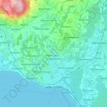
Friedrichshafen topographic map
Interactive map
Click on the map to display elevation.
About this map
Name: Friedrichshafen topographic map, elevation, terrain.
Average elevation: 442 m
Minimum elevation: 392 m
Maximum elevation: 765 m
Friedrichshafen is located on a gently curved bay on the north shore of Lake Constance and on the southwest edge of the Schussen. The city is over an altitude of 395.2 m above sea level. NHH on the shores of Lake Constance up to 501.6 m in Ailingen. The core city is located not far to the west of the confluence of the Rotach and Lake Constance. Coming from Oberteuringen, this river reaches the city west of the village of Ailingen and flows through some smaller districts before it flows into the lake on the eastern edge of the city center. The somewhat larger Schussen touches the northeast corner of the urban area.
Other topographic maps
Click on a map to view its topography, its elevation and its terrain.
Deisendorf
Germany > Baden-Württemberg > Bodenseekreis > Überlingen
Deisendorf, Überlingen, Verwaltungsgemeinschaft Überlingen, Bodenseekreis, Baden-Württemberg, 88662, Germany
Average elevation: 464 m
Tettnang
Germany > Baden-Württemberg > Bodenseekreis
Tettnang, Verwaltungsgemeinschaft Tettnang, Bodenseekreis, Baden-Württemberg, 88069, Germany
Average elevation: 457 m
Berg
Germany > Baden-Württemberg > Bodenseekreis
Berg, Kressbronn am Bodensee, Verwaltungsverband Eriskirch-Kressbronn am Bodensee-Langenargen, Bodenseekreis, Baden-Württemberg, 88079, Germany
Average elevation: 443 m
Lake Constance
Germany > Baden-Württemberg > Bodenseekreis
Lake Constance, Bodenseekreis, Baden-Württemberg, Germany
Average elevation: 555 m
Immenstaad am Bodensee
Germany > Baden-Württemberg > Bodenseekreis
Immenstaad am Bodensee, Verwaltungsgemeinschaft Friedrichshafen, Bodenseekreis, Baden-Württemberg, 88090, Germany
Average elevation: 420 m