
Make a donation
Gear up for your next adventure:
As an Amazon Associate, this site earns from qualifying purchases at no extra cost to you.
Lorgues topographic map
Click on the map to display elevation.
Make a donation
Gear up for your next adventure:
As an Amazon Associate, this site earns from qualifying purchases at no extra cost to you.
Lorgues
In terms of geology Lorgues is, for the most part, underlain by Triassic and Jurassic limestones which give rise to gentle hills and narrow flat-bottomed valleys, the most important of which are the valleys of the rivers Argens and Florièye which border the commune on the south and east. The town centre stands at an elevation of 210m, with the hill of Saint Ferréol to the east rising to 320m.
Make a donation
Gear up for your next adventure:
As an Amazon Associate, this site earns from qualifying purchases at no extra cost to you.
About this map
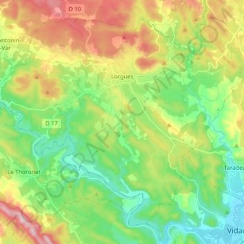
Name: Lorgues topographic map, elevation, terrain.
Average elevation: 189 m
Minimum elevation: 50 m
Maximum elevation: 428 m
Make a donation
Gear up for your next adventure:
As an Amazon Associate, this site earns from qualifying purchases at no extra cost to you.
Other topographic maps
Click on a map to view its topography, its elevation and its terrain.
Le Camp du Castellet
France > Provence-Alpes-Côte d'Azur > Var > Le Castellet
Average elevation: 371 m
Make a donation
Gear up for your next adventure:
As an Amazon Associate, this site earns from qualifying purchases at no extra cost to you.
Ruines du Barrage de Malpasset
France > Provence-Alpes-Côte d'Azur > Var > Fréjus
Average elevation: 118 m
Val d'Esquieres
France > Provence-Alpes-Côte d'Azur > Var > Roquebrune-sur-Argens
Average elevation: 82 m
Plage de Bonporteau
France > Provence-Alpes-Côte d'Azur > Var > Cavalaire-sur-Mer
Average elevation: 41 m
Make a donation
Gear up for your next adventure:
As an Amazon Associate, this site earns from qualifying purchases at no extra cost to you.
Make a donation
Gear up for your next adventure:
As an Amazon Associate, this site earns from qualifying purchases at no extra cost to you.
Make a donation
Gear up for your next adventure:
As an Amazon Associate, this site earns from qualifying purchases at no extra cost to you.
Make a donation
Gear up for your next adventure:
As an Amazon Associate, this site earns from qualifying purchases at no extra cost to you.
Les Aires Longues
France > Provence-Alpes-Côte d'Azur > Var > Ginasservis > Les Aires Longues
Average elevation: 411 m
Draguignan
France > Provence-Alpes-Côte d'Azur > Var > Draguignan > Draguignan
The elevation is 200 m. The highest hill near Draguignan is Malmont (551 m). The main river near Draguignan is the Nartuby.
Average elevation: 288 m
Île des Embiez
France > Provence-Alpes-Côte d'Azur > Var > Six-Fours-les-Plages > Le Brusc
Average elevation: 2 m
Make a donation
Gear up for your next adventure:
As an Amazon Associate, this site earns from qualifying purchases at no extra cost to you.
Fort de Brégançon
France > Provence-Alpes-Côte d'Azur > Var > Bormes-les-Mimosas
Average elevation: 9 m
Jospeh Allet
France > Provence-Alpes-Côte d'Azur > Var > Draguignan > Draguignan > Saint François
Average elevation: 207 m
Château de La Verdière
France > Provence-Alpes-Côte d'Azur > Var > La Verdière
Average elevation: 440 m
Make a donation
Gear up for your next adventure:
As an Amazon Associate, this site earns from qualifying purchases at no extra cost to you.