
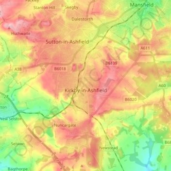
Kirkby-in-Ashfield topographic map
Interactive map
Click on the map to display elevation.
About this map
Name: Kirkby-in-Ashfield topographic map, elevation, terrain.
Average elevation: 145 m
Minimum elevation: 76 m
Maximum elevation: 205 m
Other topographic maps
Click on a map to view its topography, its elevation and its terrain.
Sutton in Ashfield
United Kingdom > England > Nottinghamshire > Ashfield > Stanton Hill
Average elevation: 154 m
Sutton Lawn
United Kingdom > England > Nottinghamshire > Ashfield > Sutton-in-Ashfield
Average elevation: 155 m
Hucknall
United Kingdom > England > Nottinghamshire > Ashfield
Hucknall Airfield, built in 1916, became RAF Hucknall. From 1927, Rolls-Royce began using the airfield for flight tests. During World War II, the aerodrome at Hucknall launched the first flight of a P-51 Mustang fitted with a Rolls-Royce Merlin Engine. The Merlin, replacing the earlier Allison V-1710 engine,…
Average elevation: 104 m