
Alvorninha topographic map
Interactive map
Click on the map to display elevation.
About this map
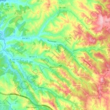
Name: Alvorninha topographic map, elevation, terrain.
Location: Alvorninha, Caldas da Rainha, Leiria, Portugal (39.35945 -9.08384 39.42362 -8.98250)
Average elevation: 125 m
Minimum elevation: 33 m
Maximum elevation: 238 m
Other topographic maps
Click on a map to view its topography, its elevation and its terrain.
Nadadouro
Portugal > Leiria > Caldas da Rainha
Nadadouro, Caldas da Rainha, Leiria, Portugal
Average elevation: 27 m
Casal Celão
Portugal > Leiria > Caldas da Rainha > Casal Celão
Casal Celão, Santo Onofre e Serra do Bouro, Caldas da Rainha, Leiria, 2500-719, Portugal
Average elevation: 57 m