
Dundalk topographic map
Interactive map
Click on the map to display elevation.
About this map
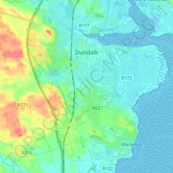
Name: Dundalk topographic map, elevation, terrain.
Location: Dundalk, County Louth, Leinster, Ireland (53.95055 -6.44438 54.02793 -6.34154)
Average elevation: 13 m
Minimum elevation: -1 m
Maximum elevation: 59 m
The main part of the census town lies at sea level. Dún Dealgan Motte at Castletown is the highest point in the urban area at an elevation of 60 m (200 ft). The municipal district includes the Cooley Mountains, with Slieve Foy the highest of the peaks at an elevation of 589 m (1,932 ft).
Other topographic maps
Click on a map to view its topography, its elevation and its terrain.
Termonfeckin
Termonfeckin, Termonfeckin ED, The Borough District of Drogheda, County Louth, Leinster, Ireland
Average elevation: 16 m
Baltray
Baltray, Termonfeckin ED, The Borough District of Drogheda, County Louth, Leinster, Ireland
Average elevation: 3 m
Tullyallen
Tullyallen, St. Peter's ED, The Borough District of Drogheda, County Louth, Leinster, Ireland
Average elevation: 49 m
The Borough District of Drogheda
The Borough District of Drogheda, County Louth, Leinster, Ireland
Average elevation: 50 m
Dundalk Poor Law Union
Dundalk Poor Law Union, County Louth, Leinster, Ireland
Average elevation: 74 m
Drogheda
Ireland > County Louth > Drogheda
Drogheda, The Borough District of Drogheda, County Louth, Leinster, A92DKR0, Ireland
Average elevation: 38 m
The Municipal District of Dundalk
The Municipal District of Dundalk, County Louth, Leinster, Ireland
Average elevation: 68 m
Dundalk
Ireland > County Louth > Dundalk
Dundalk, The Municipal District of Dundalk, County Louth, Leinster, A91 RC44, Ireland
Average elevation: 16 m
Bellurgan
Bellurgan, Ballymascanlan ED, The Municipal District of Dundalk, County Louth, Leinster, Ireland
Average elevation: 52 m
Coole
Coole, Ardee Rural ED, The Municipal District of Ardee, County Louth, Leinster, Ireland
Average elevation: 32 m
Galroostown
Galroostown, Termonfeckin ED, The Borough District of Drogheda, County Louth, Leinster, Ireland
Average elevation: 66 m
Carlingford
Ireland > County Louth > Carlingford
Carlingford, The Municipal District of Dundalk, County Louth, Leinster, A91 TRR6, Ireland
Average elevation: 84 m