
Mount Kerinci topographic map
Interactive map
Click on the map to display elevation.
About this map
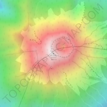
Name: Mount Kerinci topographic map, elevation, terrain.
Location: Mount Kerinci, Kerinci, Jambi, Sumatra, Indonesia (-1.69723 101.26460 -1.69713 101.26470)
Average elevation: 3,229 m
Minimum elevation: 2,658 m
Maximum elevation: 3,773 m
Mount Kerinci (also spelled Kerintji, among several other ways, and referred to as Gunung Kerinci, Gadang, Berapi Kurinci, Kerinchi, Korinci/Korintji, or Peak of Indrapura/Indrapoera) is an active stratovolcano and the highest mountain in Sumatra, Indonesia. At 12,484 ft (3,805 m) above sea level, it provides Sumatra with the fifth-highest maximum elevation of any island in the world. It is surrounded by the lush forest of Kerinci Seblat National Park, home to several endangered species including the Sumatran tiger. Mount Kerinci is ranked 32nd by topographic isolation.
Other topographic maps
Click on a map to view its topography, its elevation and its terrain.