
Pont-à-Celles topographic map
Interactive map
Click on the map to display elevation.
About this map
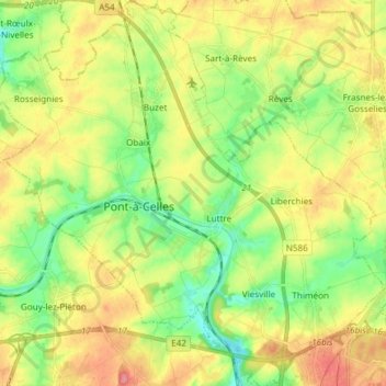
Name: Pont-à-Celles topographic map, elevation, terrain.
Location: Pont-à-Celles, Charleroi, Hainaut, Wallonia, Belgium (50.46793 4.30739 50.56288 4.45636)
Average elevation: 147 m
Minimum elevation: 112 m
Maximum elevation: 190 m
Other topographic maps
Click on a map to view its topography, its elevation and its terrain.
Forchies-la-Marche
Belgium > Hainaut > Charleroi > Fontaine-l'Évêque
Forchies-la-Marche, Fontaine-l'Évêque, Charleroi, Hainaut, Wallonia, 6141, Belgium
Average elevation: 171 m