Geolocate

Willis topographic map

Click on the map to display elevation.

About this map
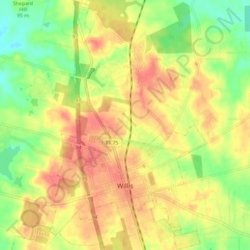
Name: Willis topographic map, elevation, terrain.

Location: Willis, Montgomery County, Texas, 77305, United States (30.40545 -95.50490 30.47810 -95.45222)

Average elevation: 99 m

Minimum elevation: 66 m

Maximum elevation: 125 m

Other topographic maps

Click on a map to view its topography, its elevation and its terrain.
New Caney

United States > Texas > Montgomery County

Average elevation: 30 m

Porter

United States > Texas > Montgomery County

Average elevation: 30 m

Mount Zion

United States > Texas > Montgomery County

Average elevation: 88 m

Bobville

United States > Texas > Montgomery County

Average elevation: 75 m

Gary

United States > Texas > Montgomery County

Average elevation: 71 m

Lakeland

United States > Texas > Montgomery County

Average elevation: 44 m

New Caney

United States > Texas > Montgomery County

Average elevation: 30 m

Conroe

United States > Texas > Montgomery County > Conroe > Conroe

Average elevation: 60 m

Porter

United States > Texas > Montgomery County

Average elevation: 30 m

New Caney

United States > Texas > Montgomery County

Average elevation: 30 m

Security

United States > Texas > Montgomery County

Average elevation: 53 m

Gear up for your next adventure:

🪢Paracord - Multi-purpose cord for camping and survival
🧢Thermal Beanie Hats - Prevent heat loss from the head in windy summit conditions
⛺Lightweight Solo Tents - Backpacking tents designed for wild camping in the UK highlands
🧊Insulated Flasks - Keeps drinks hot or cold during hikes
🥫Expedition Meals - Lightweight, high-calorie nutrition for long-distance hikers

As an Amazon Associate, this site earns from qualifying purchases at no extra cost to you.