Geolocate

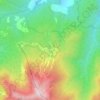
Toano topographic map

Click on the map to display elevation.

About this map
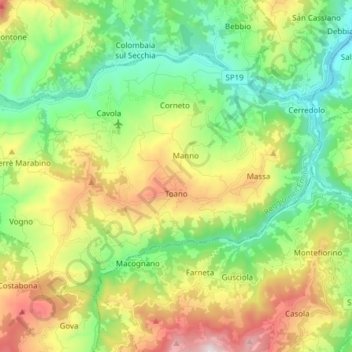
Name: Toano topographic map, elevation, terrain.

Location: Toano, Appennino Reggiano, Reggio nell'Emilia, Emilia-Romagna, Italy (44.34346 10.47131 44.42024 10.62445)

Average elevation: 595 m

Minimum elevation: 249 m

Maximum elevation: 1,219 m

Other topographic maps

Click on a map to view its topography, its elevation and its terrain.

Tagliata

Italy > Emilia-Romagna > Reggio nell'Emilia > Guastalla

Average elevation: 22 m

Iano

Italy > Emilia-Romagna > Reggio nell'Emilia > Scandiano

Average elevation: 170 m

Regnano

Italy > Emilia-Romagna > Reggio nell'Emilia

Average elevation: 386 m

Ponte Secchia

Italy > Emilia-Romagna > Reggio nell'Emilia > Baiso

Average elevation: 444 m

Vercallo

Italy > Emilia-Romagna > Reggio nell'Emilia > Cortogno

Average elevation: 511 m

Carezza

Italy > Emilia-Romagna > Reggio nell'Emilia > Pantano

Average elevation: 619 m

Cerreto Laghi

Italy > Emilia-Romagna > Reggio nell'Emilia

Average elevation: 1,320 m

Monzone

Italy > Emilia-Romagna > Reggio nell'Emilia

Average elevation: 678 m

Veggia

Italy > Emilia-Romagna > Reggio nell'Emilia > Casalgrande

Average elevation: 137 m

Gear up for your next adventure:

🧢Waterproof Hiking Hats - Keep the rain off your face while studying topographic maps
🧣Fleece Neck Warmers - Extra insulation for winter topographic surveys
📦Compression Sacks - Reduce backpack volume efficiently
⛺Camping Shelters - Emergency and lightweight shelters for outdoor use
🧴Sport Sunscreen Sticks - High-protection sunblock that won't run into your eyes on the trail

As an Amazon Associate, this site earns from qualifying purchases at no extra cost to you.