
Hermsdorf topographic map
Interactive map
Click on the map to display elevation.
About this map
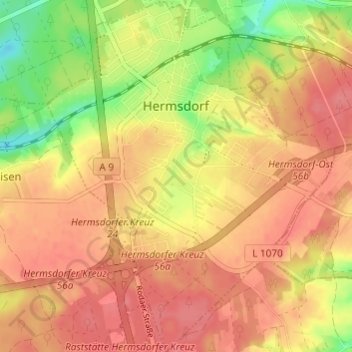
Name: Hermsdorf topographic map, elevation, terrain.
Location: Hermsdorf, Saale-Holzland-Kreis, Thuringia, Germany (50.87113 11.83453 50.90932 11.88338)
Average elevation: 339 m
Minimum elevation: 297 m
Maximum elevation: 361 m
Other topographic maps
Click on a map to view its topography, its elevation and its terrain.
Eisenberg
Germany > Thuringia > Saale-Holzland-Kreis
Eisenberg, Saale-Holzland-Kreis, Thuringia, 07607, Germany
Average elevation: 305 m