
Make a donation
Gear up for your next adventure:
As an Amazon Associate, this site earns from qualifying purchases at no extra cost to you.
Lodge Hill topographic map
Click on the map to display elevation.
Make a donation
Gear up for your next adventure:
As an Amazon Associate, this site earns from qualifying purchases at no extra cost to you.
About this map
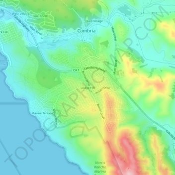
Name: Lodge Hill topographic map, elevation, terrain.
Average elevation: 63 m
Minimum elevation: 0 m
Maximum elevation: 219 m
Make a donation
Gear up for your next adventure:
As an Amazon Associate, this site earns from qualifying purchases at no extra cost to you.
Other topographic maps
Click on a map to view its topography, its elevation and its terrain.
Cambria
United States > California > San Luis Obispo County > Cambria
Because lumber production, ranching activities and mercury mining increased in the area, the village adopted the more dignified name of Cambria. Locals seem to agree that the name was contributed by a local surveyor from Cambria County, Pennsylvania, because the local topography and flora reminded him of that…
Average elevation: 58 m