
Vagamon topographic map
Interactive map
Click on the map to display elevation.
About this map
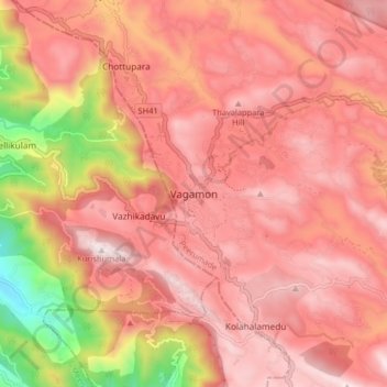
Name: Vagamon topographic map, elevation, terrain.
Location: Vagamon, Peerumade, Idukki District, Kerala, 685503, India (9.64860 76.86686 9.72860 76.94686)
Average elevation: 866 m
Minimum elevation: 179 m
Maximum elevation: 1,190 m
Vagamon, due to its elevation and climate, has a unique ecosystem, leading to the emergence of rich natural vegetation, plant species, shola forests etc. From the early 20th century plantation crops like tea, coffee started. Vagamon hills are home to less explored flora and fauna. A faunal diversity study conducted by Dr Pratheesh Mathew recorded 112 species of moths from 16 families under eight superfamilies and has become the prominent faunal diversity study in this area. The author has also recorded sightings of many species of insects, annelids, amphibians, lizards, snakes, birds and mammals. A wide variety of flowering and non-flowering plants, including rare Cycas species, has also been noted. The ongoing faunal and floral surveys are expected to shed light on the richness of biodiversity at this location. The flourishing tourism and related developments are predicted to have a negative impact on the flora and fauna of this region.
Other topographic maps
Click on a map to view its topography, its elevation and its terrain.