Geolocate

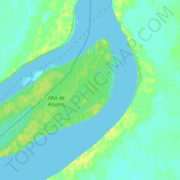
Amazon River topographic map

Click on the map to display elevation.

Amazon River

During what many archaeologists called the formative stage, Amazonian societies were deeply involved in the emergence of South America's highland agrarian systems. The trade with Andean civilizations in the terrains of the headwaters in the Andes formed an essential contribution to the social and religious development of higher-altitude civilizations like the Muisca and Incas. Early human settlements were typically based on low-lying hills or mounds.

Wikipedia (CC-BY-SA 3.0)

About this map

Name: Amazon River topographic map, elevation, terrain.

Location: Amazon River, Gurupá, Região Geográfica Imediata de Breves, Região Geográfica Intermediária de Breves, Pará, North Region, Brazil (-1.14405 -51.77840 -1.01001 -51.65806)

Average elevation: 5 m

Minimum elevation: -5 m

Maximum elevation: 24 m

Gear up for your next adventure:

🧣Neck Gaiters - Versatile protection against wind and cold
🔦Waterproof LED Headlamps - Hands-free lighting for evening treks and emergency navigation
🥾Men's Waterproof Hiking Boots - Durable footwear with deep lugs for muddy and rocky UK terrains
📍Handheld GPS Navigators - Reliable satellite navigation for hiking and off-road exploration
🧥Waterproof Hiking Jackets - Rain protection for walking in all weather conditions

As an Amazon Associate, this site earns from qualifying purchases at no extra cost to you.