Geolocate

Magtuod topographic map

Click on the map to display elevation.

About this map

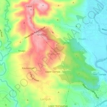
Name: Magtuod topographic map, elevation, terrain.

Location: Magtuod, Davao City, Davao Region, 8000, Philippines (7.10272 125.54573 7.14272 125.58573)

Average elevation: 94 m

Minimum elevation: 2 m

Maximum elevation: 226 m

Other topographic maps

Click on a map to view its topography, its elevation and its terrain.

Lapu-Lapu

Philippines > Davao City

Average elevation: 5 m

Matina Pangi

Philippines > Davao City

Average elevation: 53 m

Salaysay

Philippines > Davao City

Average elevation: 809 m

26-C Silangan

Philippines > Davao City

Average elevation: 4 m

Baganihan

Philippines > Davao City

Average elevation: 1,106 m

Matina Aplaya

Philippines > Davao City

Average elevation: 3 m

Marilog

Philippines > Davao City

Average elevation: 600 m

Gear up for your next adventure:

🎒Hiking Daypacks (20L) - Compact backpacks for day trips and technical mountain ascents
🪓Outdoor Multitools - Versatile tools for hiking and camping
🛌Sleeping Bags - Warm and packable sleeping bags for outdoor nights
🔥Reusable Hand Warmers - Maintain dexterity in your fingers for precise map handling
👟Waterproof Leg Gaiters - Keep mud and water out of your boots in boggy terrain

As an Amazon Associate, this site earns from qualifying purchases at no extra cost to you.