
Thank you for supporting this site ❤️
Make a donation
Make a donation
Gear up for your next adventure:
As an Amazon Associate, this site earns from qualifying purchases at no extra cost to you.
Campobasso topographic map
Click on the map to display elevation.
Thank you for supporting this site ❤️
Make a donation
Make a donation
Gear up for your next adventure:
As an Amazon Associate, this site earns from qualifying purchases at no extra cost to you.
About this map
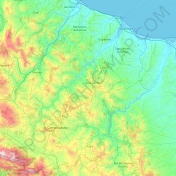
Name: Campobasso topographic map, elevation, terrain.
Location: Campobasso, Molise, Italy (41.36406 14.37773 42.07028 15.16168)
Average elevation: 435 m
Minimum elevation: -1 m
Maximum elevation: 2,014 m
Thank you for supporting this site ❤️
Make a donation
Make a donation
Gear up for your next adventure:
As an Amazon Associate, this site earns from qualifying purchases at no extra cost to you.
Other topographic maps
Click on a map to view its topography, its elevation and its terrain.
B o s c o d i M o n t e M i g l i o
Italy > Molise > Isernia > San Pietro Avellana
Average elevation: 1,008 m