Geolocate

Lima topographic map

Interactive map

Click on the map to display elevation.

Lima

The suburban district of Cieneguilla, the district of Pachacámac and the district of Chosica provide important tourist attractions among locals. Due to its elevation (over 500 masl), the sun shines in Chosica during the winter, being very visited by the residents of Lima to escape the urban fog.

Wikipedia (CC-BY-SA 3.0)

About this map

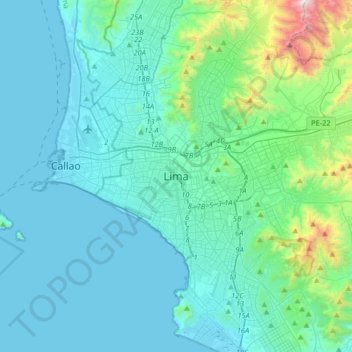
Name: Lima topographic map, elevation, terrain.

Location: Lima, Lima Metropolitan Area, Lima, 15083, Peru (-12.22211 -77.19653 -11.90211 -76.87653)

Average elevation: 202 m

Minimum elevation: 0 m

Maximum elevation: 1,638 m

Other topographic maps

Click on a map to view its topography, its elevation and its terrain.

Province of Huaral

Peru > Lima

Average elevation: 2,414 m

Parque Villa Corpac

Peru > Lima

Average elevation: 191 m

Huacho

Peru > Lima

Average elevation: 69 m

San Martín de Porres

Peru > Lima > Lima

Average elevation: 55 m

Antioquía

Peru > Lima

Average elevation: 2,307 m

Villa El Salvador

Peru > Lima

Average elevation: 123 m

Calango

Peru > Lima

Average elevation: 1,059 m

Lima

Peru > Lima > Lima Metropolitan Area

Average elevation: 141 m

La Victoria

Peru > Lima > Lima

Average elevation: 137 m

Santiago de Surco

Peru > Lima > Lima

Average elevation: 159 m

San Martín de Porres

Peru > Lima > Lima

Average elevation: 55 m

Punta Negra

Peru > Lima

Average elevation: 631 m

Magdalena del Mar

Peru > Lima

Average elevation: 49 m

N

Peru > Lima

Average elevation: 147 m

Aucallama

Peru > Lima

Average elevation: 490 m

Lurín

Peru > Lima

Average elevation: 240 m

Pachacámac

Peru > Lima > Santa Anita

The district is located in the southern part of the Lima province at an elevation of 75m.

Average elevation: 442 m

Breña

Peru > Lima > Lima

Average elevation: 129 m

Sacred City of Caral-Supe

Peru > Lima > Supe > Caral

Average elevation: 393 m

Supe River

Peru > Lima

Average elevation: 1,832 m

Supe

Peru > Lima

Average elevation: 161 m

Miraflores

Peru > Lima > Lima

Average elevation: 73 m

Rímac River

Peru > Lima

The Rímac River begins its journey on the western slope of the Andes mountain range at an altitude of approximately 5,508 mamsl in the Nevado Paca, touring the provinces of Lima and Huarochirí, both located in the department of Lima. Among the most important tributaries of the Rímac are the Santa Eulalia…

Average elevation: 2,779 m

Villa María del Triunfo

Peru > Lima

Average elevation: 275 m

Province of Huaura

Peru > Lima

Average elevation: 1,510 m

Lima

Peru > Lima

Average elevation: 141 m

Lima Metropolitan Area

Peru > Lima

Average elevation: 591 m

Antioquía

Peru > Lima

Average elevation: 2,307 m

Province of Lima

Peru > Lima

Average elevation: 1,234 m

Province of Canta

Peru > Lima

Average elevation: 3,070 m

Lachay Hills

Peru > Lima > Huacho

Average elevation: 384 m

Lima Metropolitan Area

Peru > Lima

Average elevation: 591 m

Chicla

Peru > Lima

Average elevation: 4,595 m

Province of Lima

Peru > Lima

Average elevation: 1,234 m

Coayllo

Peru > Lima

Average elevation: 1,140 m

Province of Lima

Peru > Lima > Lima Metropolitan Area

Average elevation: 1,234 m

La Molina

Peru > Lima > Lima Metropolitan Area

Average elevation: 443 m

Province of Lima

Peru > Lima

Average elevation: 1,234 m

Province of Lima

Peru > Lima

Average elevation: 1,234 m

D

Peru > Lima > Lima Metropolitan Area

Average elevation: 56 m

Province of Lima

Peru > Lima

Average elevation: 1,234 m

Barranca

Peru > Lima

Average elevation: 115 m

Parque Ecológico La Molina

Peru > Lima > La Molina

Average elevation: 538 m

Lurín

Peru > Lima

Average elevation: 240 m

Pucusana

Peru > Lima

Average elevation: 31 m

Pativilca

Peru > Lima

Average elevation: 195 m

Lima Metropolitan Area

Peru > Lima

Average elevation: 1,234 m

Breña

Peru > Lima

Average elevation: 122 m

Asia

Peru > Lima

Average elevation: 367 m

Plaza de Armas de Lurín

Peru > Lima > Lurín

Average elevation: 17 m

Lunahuaná

Peru > Lima

Average elevation: 1,309 m

Los Olivos

Peru > Lima > Lima

Average elevation: 142 m

playa

Peru > Lima > Supe

Average elevation: 17 m

Zona Reservada Cordillera Huayhuash

Peru > Lima > Cajatambo

Average elevation: 4,319 m

Lima

Peru > Lima

Average elevation: 141 m

Huacho

Peru > Lima

Average elevation: 69 m

Ancón

Peru > Lima > Lima Metropolitan Area

Average elevation: 542 m

Province of Huarochirí

Peru > Lima

Average elevation: 3,205 m

Puente Piedra

Peru > Lima

Average elevation: 237 m

San Antonio

Peru > Lima > San Antonio

Average elevation: 128 m

El Agustino

Peru > Lima > El Agustino

Average elevation: 228 m

Playa La Herradura

Peru > Lima > Chorrillos

Average elevation: 52 m

San Isidro

Peru > Lima > San Isidro

Average elevation: 101 m

La Huaca

Peru > Lima > Mala > La Huaca

Average elevation: 14 m

Ate

Peru > Lima

Average elevation: 542 m

Jesús María

Peru > Lima

Average elevation: 110 m

Chorrillos

Peru > Lima > Lima Metropolitan Area

Average elevation: 34 m

Magdalena del Mar

Peru > Lima

Average elevation: 49 m

San Juan de Miraflores

Peru > Lima

Average elevation: 158 m

Lince

Peru > Lima

Average elevation: 116 m

San Borja

Peru > Lima

Average elevation: 162 m

San Juan de Miraflores

Peru > Lima

Average elevation: 158 m

Villa El Salvador

Peru > Lima > Lima Metropolitan Area

Average elevation: 104 m

Comas

Peru > Lima

Average elevation: 273 m

Caleta de Carquín

Peru > Lima > Caleta de Carquín

Average elevation: 12 m

Province of Huarochirí

Peru > Lima

Average elevation: 3,205 m

Leoncio Prado

Peru > Lima > Leoncio Prado

Average elevation: 3,440 m

Los Olivos

Peru > Lima > Lima

Average elevation: 152 m

Villa María del Triunfo

Peru > Lima

Average elevation: 275 m

Laguna de Novios

Peru > Lima > San Isidro

Average elevation: 107 m

Parque Artigas

Peru > Lima > Jesús María

Average elevation: 116 m

Miraflores

Peru > Lima

Average elevation: 79 m

Rímac

Peru > Lima

Average elevation: 198 m

Cerro Azul

Peru > Lima

Average elevation: 114 m

Chaclacayo

Peru > Lima > Chaclacayo

Average elevation: 1,048 m

Carabayllo

Peru > Lima > Lima Metropolitan Area

Carabayllo was the first district to be created by decree in the Lima Province by General José de San Martín in the independence era on August 4, 1821. At that time the district occupied the whole Chillón valley north of the Rímac River up to the Canta province. In principle, the district was the only one…

Average elevation: 800 m

Sacred City of Caral-Supe

Peru > Lima > Supe > Caral

Average elevation: 393 m

Humedal Santa Rosa

Peru > Lima > Chancay

Average elevation: 20 m

Province of Cañete

Peru > Lima

Average elevation: 1,346 m

Huarochirí

Peru > Lima

Average elevation: 4,238 m

Ate

Peru > Lima > Lima Metropolitan Area

Average elevation: 542 m

Carabayllo

Peru > Lima

Carabayllo was the first district to be created by decree in the Lima Province by General José de San Martín in the independence era on August 4, 1821. At that time the district occupied the whole Chillón valley north of the Rímac River up to the Canta province. In principle, the district was the only one…

Average elevation: 800 m

Ate

Peru > Lima

Average elevation: 542 m