
Make a donation
Gear up for your next adventure:
As an Amazon Associate, this site earns from qualifying purchases at no extra cost to you.
Kayseri topographic map
Click on the map to display elevation.
Make a donation
Gear up for your next adventure:
As an Amazon Associate, this site earns from qualifying purchases at no extra cost to you.
Kayseri
Kayseri has a cold semi-arid climate, Köppen climate classification (BSk) with cold, snowy winters and hot, dry summers with cool nights due to Kayseri's high elevation. Rainfall occurs mostly during the spring, early summer and late autumn.
Make a donation
Gear up for your next adventure:
As an Amazon Associate, this site earns from qualifying purchases at no extra cost to you.
About this map
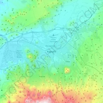
Name: Kayseri topographic map, elevation, terrain.
Average elevation: 1,345 m
Minimum elevation: 1,013 m
Maximum elevation: 2,795 m
Make a donation
Gear up for your next adventure:
As an Amazon Associate, this site earns from qualifying purchases at no extra cost to you.
Other topographic maps
Click on a map to view its topography, its elevation and its terrain.