
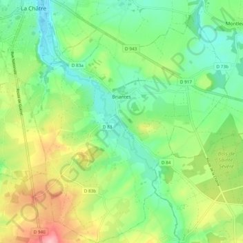
Briantes topographic map
Interactive map
Click on the map to display elevation.
About this map
Name: Briantes topographic map, elevation, terrain.
Average elevation: 251 m
Minimum elevation: 202 m
Maximum elevation: 341 m
Other topographic maps
Click on a map to view its topography, its elevation and its terrain.
Langé
France > Centre-Val de Loire > Indre
Langé, Châteauroux, Indre, Centre-Val de Loire, Metropolitan France, 36600, France
Average elevation: 143 m
Gournay
France > Centre-Val de Loire > Indre
Gournay, La Châtre, Indre, Centre-Val de Loire, Metropolitan France, 36230, France
Average elevation: 206 m
Champ de Crozon
France > Centre-Val de Loire > Indre > Crozon-sur-Vauvre
Champ de Crozon, Bévet, Crozon-sur-Vauvre, La Châtre, Indre, Centre-Val de Loire, Metropolitan France, 36140, France
Average elevation: 318 m
Les Illions
France > Centre-Val de Loire > Indre > Buzançais > Saint-Étienne
Les Illions, Saint-Étienne, Buzançais, Châteauroux, Indre, Centre-Val de Loire, Metropolitan France, 36500, France
Average elevation: 117 m
Buzançais
France > Centre-Val de Loire > Indre
Buzançais, Châteauroux, Indre, Centre-Val de Loire, Metropolitan France, 36500, France
Average elevation: 130 m
Saint-Plantaire
France > Centre-Val de Loire > Indre
Saint-Plantaire, La Châtre, Indre, Centre-Val de Loire, Metropolitan France, 36190, France
Average elevation: 295 m
La Broue
France > Centre-Val de Loire > Indre > Cuzion
La Broue, Cuzion, Châteauroux, Indre, Centre-Val de Loire, Metropolitan France, 36190, France
Average elevation: 260 m
Champarnoux
France > Centre-Val de Loire > Indre > Saint-Plantaire
Champarnoux, Saint-Plantaire, La Châtre, Indre, Centre-Val de Loire, Metropolitan France, 36190, France
Average elevation: 265 m
Éguzon-Chantôme
France > Centre-Val de Loire > Indre
Éguzon-Chantôme, Châteauroux, Indre, Centre-Val de Loire, Metropolitan France, 36270, France
Average elevation: 264 m
Le Blanc
France > Centre-Val de Loire > Indre
Le Blanc, Indre, Centre-Val de Loire, Metropolitan France, 36300, France
Average elevation: 111 m
Concremiers
France > Centre-Val de Loire > Indre
Concremiers, Le Blanc, Indre, Centre-Val de Loire, Metropolitan France, 36300, France
Average elevation: 112 m
Montlevicq
France > Centre-Val de Loire > Indre > Montlevicq
Montlevicq, La Châtre, Indre, Centre-Val de Loire, Metropolitan France, 36400, France
Average elevation: 230 m
Lacs
France > Centre-Val de Loire > Indre
Lacs, La Châtre, Indre, Centre-Val de Loire, Metropolitan France, 36400, France
Average elevation: 224 m
Crozon-sur-Vauvre
France > Centre-Val de Loire > Indre
Crozon-sur-Vauvre, La Châtre, Indre, Centre-Val de Loire, Metropolitan France, 36140, France
Average elevation: 348 m
La Morijo
France > Centre-Val de Loire > Indre > Cuzion > La Jarrige
La Morijo, La Jarrige, Cuzion, Châteauroux, Indre, Centre-Val de Loire, Metropolitan France, 36190, France
Average elevation: 226 m
Fontgombault
France > Centre-Val de Loire > Indre
Fontgombault, Le Blanc, Indre, Centre-Val de Loire, Metropolitan France, 36220, France
Average elevation: 112 m
Saint-Gaultier
France > Centre-Val de Loire > Indre
Saint-Gaultier, Le Blanc, Indre, Centre-Val de Loire, Metropolitan France, 36800, France
Average elevation: 134 m
Châteauroux
France > Centre-Val de Loire > Indre > Châteauroux
Châteauroux, Indre, Centre-Val de Loire, Metropolitan France, 36000, France
Average elevation: 153 m