
Alfândega da Fé topographic map
Interactive map
Click on the map to display elevation.
About this map
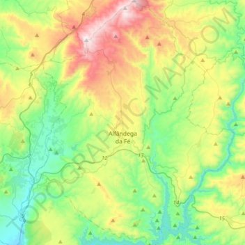
Name: Alfândega da Fé topographic map, elevation, terrain.
Location: Alfândega da Fé, Bragança, Portugal (41.23940 -7.06955 41.47173 -6.82048)
Average elevation: 479 m
Minimum elevation: 122 m
Maximum elevation: 1,194 m
Other topographic maps
Click on a map to view its topography, its elevation and its terrain.