
Make a donation
Gear up for your next adventure:
As an Amazon Associate, this site earns from qualifying purchases at no extra cost to you.
Ibiza topographic map
Click on the map to display elevation.
Make a donation
Gear up for your next adventure:
As an Amazon Associate, this site earns from qualifying purchases at no extra cost to you.
About this map
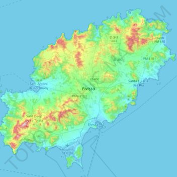
Name: Ibiza topographic map, elevation, terrain.
Location: Ibiza, Balearic Islands, Spain (38.83042 1.21327 39.11841 1.62159)
Average elevation: 52 m
Minimum elevation: -4 m
Maximum elevation: 470 m
Make a donation
Gear up for your next adventure:
As an Amazon Associate, this site earns from qualifying purchases at no extra cost to you.
Other topographic maps
Click on a map to view its topography, its elevation and its terrain.
Urbanització Puig de Can Vinyets
Spain > Balearic Islands > Ibiza > Santa Eulària des Riu
Average elevation: 32 m
Make a donation
Gear up for your next adventure:
As an Amazon Associate, this site earns from qualifying purchases at no extra cost to you.
Cala Grassio
Spain > Balearic Islands > Ibiza > Sant Antoni de Portmany > Can Germà > Cap Negret
Average elevation: 23 m
Make a donation
Gear up for your next adventure:
As an Amazon Associate, this site earns from qualifying purchases at no extra cost to you.