
Clanwilliam topographic map
Click on the map to display elevation.
Clanwilliam
Clanwilliam is situated at an elevation of 100 metres (330 ft), between the western slopes of the Cederberg mountains and the east bank of the Olifants River, which is impounded there by the Clanwilliam Dam. It lies just off the N7 national road, which runs from Cape Town to the Namibian border, and on the R364 road, which runs from Lamberts Bay to Calvinia. Clanwilliam is 230 kilometres (140 mi) from Cape Town by road.
About this map
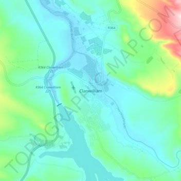
Name: Clanwilliam topographic map, elevation, terrain.
Average elevation: 162 m
Minimum elevation: 72 m
Maximum elevation: 536 m
Other topographic maps
Click on a map to view its topography, its elevation and its terrain.
Bulshoek Dam
South Africa > Western Cape > West Coast District Municipality > Cederberg Local Municipality
Average elevation: 184 m
Cederberg Ward 1
South Africa > Western Cape > West Coast District Municipality > Cederberg Local Municipality
Average elevation: 690 m
Clanwilliam Dam
South Africa > Western Cape > West Coast District Municipality > Cederberg Local Municipality > Clanwilliam
Average elevation: 289 m
Krom
South Africa > Western Cape > West Coast District Municipality > Cederberg Local Municipality
Average elevation: 870 m