
Thank you for supporting this site ❤️
Make a donation
Make a donation
Gear up for your next adventure:
As an Amazon Associate, this site earns from qualifying purchases at no extra cost to you.
Dahanu topographic map
Click on the map to display elevation.
Thank you for supporting this site ❤️
Make a donation
Make a donation
Gear up for your next adventure:
As an Amazon Associate, this site earns from qualifying purchases at no extra cost to you.
Dahanu
Dahanu is located at 19°58′N 72°44′E / 19.97°N 72.73°E / 19.97; 72.73. It has an average elevation of 9.89 metres.
Thank you for supporting this site ❤️
Make a donation
Make a donation
Gear up for your next adventure:
As an Amazon Associate, this site earns from qualifying purchases at no extra cost to you.
About this map
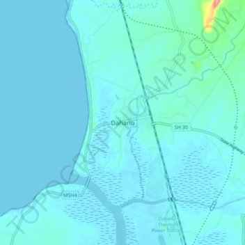
Name: Dahanu topographic map, elevation, terrain.
Location: Dahanu, Dahanu Taluka, Palghar, Maharashtra, 401600, India (19.94872 72.69385 20.02872 72.77385)
Average elevation: 9 m
Minimum elevation: -2 m
Maximum elevation: 122 m
Thank you for supporting this site ❤️
Make a donation
Make a donation
Gear up for your next adventure:
As an Amazon Associate, this site earns from qualifying purchases at no extra cost to you.