
Make a donation
Gear up for your next adventure:
As an Amazon Associate, this site earns from qualifying purchases at no extra cost to you.
Neretva topographic map
Click on the map to display elevation.
Make a donation
Gear up for your next adventure:
As an Amazon Associate, this site earns from qualifying purchases at no extra cost to you.
Neretva
Its source and headwaters gorge are situated deep in the Dinaric Alps at the base of the Zelengora and Lebršnik mountains, specifically under the Gredelj saddle. The river source is at 1,227 meters above sea level and consists of five small and distinct wellsprings. On its 90 kilometers course through the first section the Neretva cuts two distinct deep and narrow canyons and two distinct wide and fertile valleys, around Ulog and then Župa Komska, wider area around Glavatičevo, before it reaches the town of Konjic. This section is also better known as the Upper Neretva (Serbo-Croatian: Gornja Neretva), and here the river flows generally from east-southeast to north-northwest as do most rivers in Bosnia and Herzegovina belonging to the Danube watershed, and covers some 1,390 square kilometres (540 sq mi) with an average elevation of 1.2%. Right below Konjic, the Neretva again expands into a third and largest valley which provided fertile agricultural land before it was flooded by large artificial reservoir, Jablaničko Lake, formed after construction of a Jablanica Dam near town of Jablanica.
Make a donation
Gear up for your next adventure:
As an Amazon Associate, this site earns from qualifying purchases at no extra cost to you.
About this map
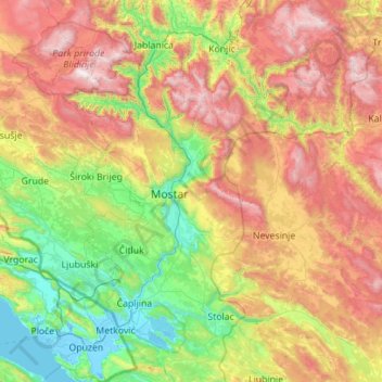
Name: Neretva topographic map, elevation, terrain.
Average elevation: 786 m
Minimum elevation: -4 m
Maximum elevation: 2,192 m
Make a donation
Gear up for your next adventure:
As an Amazon Associate, this site earns from qualifying purchases at no extra cost to you.
Other topographic maps
Click on a map to view its topography, its elevation and its terrain.
Una
Bosnia and Herzegovina > Federation of Bosnia and Herzegovina > City of Bihać > Bihać
Average elevation: 255 m
Tuzla
Bosnia and Herzegovina > Federation of Bosnia and Herzegovina > City of Tuzla
Average elevation: 349 m
Una
Bosnia and Herzegovina > Federation of Bosnia and Herzegovina > City of Bihać > Bihać
Average elevation: 255 m
Make a donation
Gear up for your next adventure:
As an Amazon Associate, this site earns from qualifying purchases at no extra cost to you.
Gračanica
Bosnia and Herzegovina > Federation of Bosnia and Herzegovina > Town of Gračanica
Average elevation: 267 m
Vrbljani
Bosnia and Herzegovina > Federation of Bosnia and Herzegovina > Town of Konjic
Average elevation: 727 m
Gudelji
Bosnia and Herzegovina > Federation of Bosnia and Herzegovina > Jazvine
Average elevation: 472 m
Make a donation
Gear up for your next adventure:
As an Amazon Associate, this site earns from qualifying purchases at no extra cost to you.
Brđani
Bosnia and Herzegovina > Federation of Bosnia and Herzegovina > City of Tuzla
Average elevation: 370 m
Gornja Bukovica
Bosnia and Herzegovina > Federation of Bosnia and Herzegovina
Average elevation: 492 m
Lukavac
Bosnia and Herzegovina > Federation of Bosnia and Herzegovina > Town of Lukavac
Average elevation: 222 m
Make a donation
Gear up for your next adventure:
As an Amazon Associate, this site earns from qualifying purchases at no extra cost to you.
Plane
Bosnia and Herzegovina > Federation of Bosnia and Herzegovina > City of Tuzla
Average elevation: 240 m
Visoko
Bosnia and Herzegovina > Federation of Bosnia and Herzegovina > Grad Visoko
The Visoko municipality covers 232 square kilometres with several characteristic, morphologically distinctive valleys formed by the foothills of the Central Bosnian mountains including Ozren, Vranica and Zvijezda. The altitude of the region ranges from 400 to 1,050 metres. Visoko's natural environment is…
Average elevation: 527 m
Make a donation
Gear up for your next adventure:
As an Amazon Associate, this site earns from qualifying purchases at no extra cost to you.
Podorašac
Bosnia and Herzegovina > Federation of Bosnia and Herzegovina > Town of Konjic
Average elevation: 641 m
Greb
Bosnia and Herzegovina > Federation of Bosnia and Herzegovina > Markovići
Average elevation: 981 m
Vareš
Bosnia and Herzegovina > Federation of Bosnia and Herzegovina
The Vareš region also has possibilities for winter tourism development. Due to its position and elevation snow stays longer than in other regions, and the beautiful areas surrounding it are really good for skiing and skating. The mountain resort Doli is located on Zvijezda Mountain.
Average elevation: 1,091 m
Brgule
Bosnia and Herzegovina > Federation of Bosnia and Herzegovina > City of Tuzla
Average elevation: 265 m
Make a donation
Gear up for your next adventure:
As an Amazon Associate, this site earns from qualifying purchases at no extra cost to you.
Banjani
Bosnia and Herzegovina > Federation of Bosnia and Herzegovina > Town of Bosanska Krupa
Average elevation: 308 m
Livno
Bosnia and Herzegovina > Federation of Bosnia and Herzegovina > City of Livno
Average elevation: 907 m
Dinaric Alps
Bosnia and Herzegovina > Federation of Bosnia and Herzegovina > City of Livno
Average elevation: 1,599 m
Make a donation
Gear up for your next adventure:
As an Amazon Associate, this site earns from qualifying purchases at no extra cost to you.
Tuzla
Bosnia and Herzegovina > Federation of Bosnia and Herzegovina > City of Tuzla
Average elevation: 349 m
Make a donation
Gear up for your next adventure:
As an Amazon Associate, this site earns from qualifying purchases at no extra cost to you.
Čapljina
Bosnia and Herzegovina > Federation of Bosnia and Herzegovina > City of Čapljina
Average elevation: 98 m
Dinaric Alps
Bosnia and Herzegovina > Federation of Bosnia and Herzegovina > City of Livno
Average elevation: 1,599 m
Dubovo brdo
Bosnia and Herzegovina > Federation of Bosnia and Herzegovina > City of Čapljina > Trebižat
Average elevation: 149 m
Make a donation
Gear up for your next adventure:
As an Amazon Associate, this site earns from qualifying purchases at no extra cost to you.
Donje Vukovsko
Bosnia and Herzegovina > Federation of Bosnia and Herzegovina
Average elevation: 1,241 m
Mošćanica
Bosnia and Herzegovina > Federation of Bosnia and Herzegovina > City of Zenica
Average elevation: 645 m
Make a donation
Gear up for your next adventure:
As an Amazon Associate, this site earns from qualifying purchases at no extra cost to you.
Drvar
Bosnia and Herzegovina > Federation of Bosnia and Herzegovina
This extremely hilly region, comprising the town of Drvar and the numerous outlying villages, covers approximately 1,030 square kilometres (400 square miles). The town is mainly situated on the left side of the River Unac, and its elevation is approximately 480 meters (1,574 feet).
Average elevation: 692 m
Make a donation
Gear up for your next adventure:
As an Amazon Associate, this site earns from qualifying purchases at no extra cost to you.
Gornji Vakuf-Uskoplje
Bosnia and Herzegovina > Federation of Bosnia and Herzegovina
Average elevation: 869 m
Prenj
Bosnia and Herzegovina > Federation of Bosnia and Herzegovina > Town of Stolac
Average elevation: 169 m
Hodbina
Bosnia and Herzegovina > Federation of Bosnia and Herzegovina > City of Mostar
Average elevation: 127 m
Make a donation
Gear up for your next adventure:
As an Amazon Associate, this site earns from qualifying purchases at no extra cost to you.
Tešanj
Bosnia and Herzegovina > Federation of Bosnia and Herzegovina
Tešanj is located at an altitude of 230 meters and was built around the river Tešanjka. The town is surrounded by many hills.
Average elevation: 294 m
Cazin
Bosnia and Herzegovina > Federation of Bosnia and Herzegovina > City of Cazin
Average elevation: 375 m
Konjic
Bosnia and Herzegovina > Federation of Bosnia and Herzegovina > Town of Konjic
Average elevation: 550 m
Krušćica
Bosnia and Herzegovina > Federation of Bosnia and Herzegovina > Town of Konjic
Average elevation: 1,034 m
Make a donation
Gear up for your next adventure:
As an Amazon Associate, this site earns from qualifying purchases at no extra cost to you.
Hasanovići
Bosnia and Herzegovina > Federation of Bosnia and Herzegovina > Town of Konjic
Average elevation: 954 m
Livno
Bosnia and Herzegovina > Federation of Bosnia and Herzegovina > City of Livno
Average elevation: 907 m
Rodoč
Bosnia and Herzegovina > Federation of Bosnia and Herzegovina > City of Mostar > Local community Rodoč I
Average elevation: 132 m
Make a donation
Gear up for your next adventure:
As an Amazon Associate, this site earns from qualifying purchases at no extra cost to you.
Dinara
Bosnia and Herzegovina > Federation of Bosnia and Herzegovina > City of Livno
Average elevation: 952 m
Make a donation
Gear up for your next adventure:
As an Amazon Associate, this site earns from qualifying purchases at no extra cost to you.
Međugorje
Bosnia and Herzegovina > Federation of Bosnia and Herzegovina
The name Medjugorje literally means "between mountains". At an altitude of 200 m (660 ft) above sea level it has a mild Mediterranean climate. The town consists of an ethnically homogeneous Croat population of 2,306. The Catholic parish includes four neighbouring villages: Bijakovići, Vionica, Miletina and…
Average elevation: 203 m
Bosanski Milanovac
Bosnia and Herzegovina > Federation of Bosnia and Herzegovina
Average elevation: 532 m
Jablanica
Bosnia and Herzegovina > Federation of Bosnia and Herzegovina
The mean elevation of Jablanica is 202 metres (663 ft) above sea level. Some 69% of the municipality's land area (approx. 93 km²) is forested. The Jablanica lake is an important geographical as well as economic presence in Jablanica.
Average elevation: 468 m
Make a donation
Gear up for your next adventure:
As an Amazon Associate, this site earns from qualifying purchases at no extra cost to you.
Mramor
Bosnia and Herzegovina > Federation of Bosnia and Herzegovina > City of Tuzla
Average elevation: 297 m
Kraljeva Sutjeska
Bosnia and Herzegovina > Federation of Bosnia and Herzegovina
Average elevation: 695 m
Make a donation
Gear up for your next adventure:
As an Amazon Associate, this site earns from qualifying purchases at no extra cost to you.
Tuzla
Bosnia and Herzegovina > Federation of Bosnia and Herzegovina > City of Tuzla
Average elevation: 349 m
Visoko
Bosnia and Herzegovina > Federation of Bosnia and Herzegovina > Grad Visoko
The Visoko municipality covers 232 square kilometres with several characteristic, morphologically distinctive valleys formed by the foothills of the Central Bosnian mountains including Ozren, Vranica and Zvijezda. The altitude of the region ranges from 400 to 1,050 metres. Visoko's natural environment is…
Average elevation: 527 m
Mrkovići
Bosnia and Herzegovina > Federation of Bosnia and Herzegovina > City of Sarajevo
Average elevation: 938 m
Make a donation
Gear up for your next adventure:
As an Amazon Associate, this site earns from qualifying purchases at no extra cost to you.
Ljubuški
Bosnia and Herzegovina > Federation of Bosnia and Herzegovina > Grad Ljubuški
Average elevation: 133 m
Make a donation
Gear up for your next adventure:
As an Amazon Associate, this site earns from qualifying purchases at no extra cost to you.
Kromolj
Bosnia and Herzegovina > Federation of Bosnia and Herzegovina > City of Sarajevo > Radava
Average elevation: 758 m
Dinara
Bosnia and Herzegovina > Federation of Bosnia and Herzegovina > City of Livno
Average elevation: 952 m
Make a donation
Gear up for your next adventure:
As an Amazon Associate, this site earns from qualifying purchases at no extra cost to you.
Tukovi
Bosnia and Herzegovina > Federation of Bosnia and Herzegovina > City of Bihać
Average elevation: 831 m
Make a donation
Gear up for your next adventure:
As an Amazon Associate, this site earns from qualifying purchases at no extra cost to you.
Drvar
Bosnia and Herzegovina > Federation of Bosnia and Herzegovina
This extremely hilly region comprising the town of Drvar and the numerous outlying villages covers approximately 1,030 square kilometers (400 square miles). The town itself is mainly spread out from the left side of the river Unac, and its elevation is approximately 480 meters (1,574 feet).
Average elevation: 692 m
Make a donation
Gear up for your next adventure:
As an Amazon Associate, this site earns from qualifying purchases at no extra cost to you.
Trubar
Bosnia and Herzegovina > Federation of Bosnia and Herzegovina > City of Bihać
Average elevation: 692 m
Ljubuški
Bosnia and Herzegovina > Federation of Bosnia and Herzegovina > Grad Ljubuški
Average elevation: 133 m
Make a donation
Gear up for your next adventure:
As an Amazon Associate, this site earns from qualifying purchases at no extra cost to you.
Prenj
Bosnia and Herzegovina > Federation of Bosnia and Herzegovina > Town of Stolac
Average elevation: 169 m
Ripač
Bosnia and Herzegovina > Federation of Bosnia and Herzegovina > City of Bihać
Average elevation: 316 m
Mlakva
Bosnia and Herzegovina > Federation of Bosnia and Herzegovina > Kute
Average elevation: 1,260 m
Make a donation
Gear up for your next adventure:
As an Amazon Associate, this site earns from qualifying purchases at no extra cost to you.
Nahorevo
Bosnia and Herzegovina > Federation of Bosnia and Herzegovina > City of Sarajevo
Average elevation: 864 m
Svinjašnica
Bosnia and Herzegovina > Federation of Bosnia and Herzegovina > Town of Zavidovići
Average elevation: 446 m
Make a donation
Gear up for your next adventure:
As an Amazon Associate, this site earns from qualifying purchases at no extra cost to you.
Kupres
Bosnia and Herzegovina > Federation of Bosnia and Herzegovina
Kupres is located at an altitude between 1,120 and 1,250 m (3,675 and 4,101 ft) and averages 55 days a year of snowfall due to its advantageous location in the Dinaric Alps.
Average elevation: 1,254 m
Brgule
Bosnia and Herzegovina > Federation of Bosnia and Herzegovina > City of Tuzla
Average elevation: 265 m
Brgule
Bosnia and Herzegovina > Federation of Bosnia and Herzegovina > City of Tuzla
Average elevation: 265 m
Make a donation
Gear up for your next adventure:
As an Amazon Associate, this site earns from qualifying purchases at no extra cost to you.