Geolocate

Timbugan topographic map

Click on the map to display elevation.

About this map

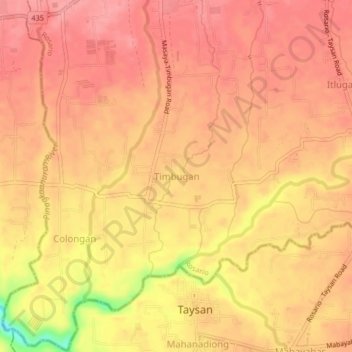
Name: Timbugan topographic map, elevation, terrain.

Location: Timbugan, Rosario, Batangas, Calabarzon, 4225, Philippines (13.79280 121.16683 13.83280 121.20683)

Average elevation: 117 m

Minimum elevation: 48 m

Maximum elevation: 140 m

Gear up for your next adventure:

🥤Collapsible Water Bottles - Save space in your rucksack as you consume your water
🧗Locking Carabiners - Secure gear to your pack or for light technical use
🥾Walking Shoes - Lightweight walking shoes for countryside and coastal paths
🥼Base Layers - Thermal base layers for temperature regulation
🧢Waterproof Hiking Hats - Keep the rain off your face while studying topographic maps

As an Amazon Associate, this site earns from qualifying purchases at no extra cost to you.