
Make a donation
Gear up for your next adventure:
As an Amazon Associate, this site earns from qualifying purchases at no extra cost to you.
Pendle Hill topographic map
Click on the map to display elevation.
Make a donation
Gear up for your next adventure:
As an Amazon Associate, this site earns from qualifying purchases at no extra cost to you.
About this map
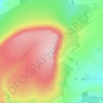
Name: Pendle Hill topographic map, elevation, terrain.
Average elevation: 385 m
Minimum elevation: 211 m
Maximum elevation: 557 m
Lancashire trails, hiking, mountain biking, running and outdoor activities
Make a donation
Gear up for your next adventure:
As an Amazon Associate, this site earns from qualifying purchases at no extra cost to you.
Other topographic maps
Click on a map to view its topography, its elevation and its terrain.
Colne Water
United Kingdom > England > Lancashire > Borough of Pendle > Laneshaw Bridge
Average elevation: 202 m
Laneshaw Bridge
United Kingdom > England > Lancashire > Borough of Pendle > Laneshaw Bridge
Average elevation: 269 m
Make a donation
Gear up for your next adventure:
As an Amazon Associate, this site earns from qualifying purchases at no extra cost to you.
Barnoldswick
United Kingdom > England > Lancashire > Borough of Pendle > Salterforth
Average elevation: 175 m
Colne
United Kingdom > England > Lancashire > Borough of Pendle
Pendle Leisure Trust runs the Pendle Leisure Centre next to the railway station. The facility has two swimming pools, a fitness centre and gymnasium, sauna and sports hall. In summer 2013, the outdoor all-weather pitch was replaced by Urban Altitude. This outdoor aerial assault course is the first of its kind…
Average elevation: 197 m
Barrowford
United Kingdom > England > Lancashire > Borough of Pendle > Barrowford
Average elevation: 161 m
Make a donation
Gear up for your next adventure:
As an Amazon Associate, this site earns from qualifying purchases at no extra cost to you.
Colne
United Kingdom > England > Lancashire > Borough of Pendle
Pendle Leisure Trust runs the Pendle Leisure Centre next to the railway station. The facility has two swimming pools, a fitness centre and gymnasium, sauna and sports hall. In summer 2013, the outdoor all-weather pitch was replaced by Urban Altitude. This outdoor aerial assault course is the first of its kind…
Average elevation: 197 m
Barnoldswick
United Kingdom > England > Lancashire > Borough of Pendle > Salterforth
Average elevation: 175 m