Geolocate

Athens topographic map

Click on the map to display elevation.

About this map

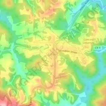
Name: Athens topographic map, elevation, terrain.

Location: Athens, Mercer County, West Virginia, United States (37.41624 -81.02576 37.42920 -81.00565)

Average elevation: 759 m

Minimum elevation: 696 m

Maximum elevation: 832 m

Other topographic maps

Click on a map to view its topography, its elevation and its terrain.

Flipping

United States > West Virginia > Mercer County > Montcalm

Average elevation: 752 m

Rock

United States > West Virginia > Mercer County

Average elevation: 760 m

Flat Top

United States > West Virginia > Mercer County

Average elevation: 962 m

Beeson

United States > West Virginia > Mercer County

Average elevation: 798 m

Freeman

United States > West Virginia > Mercer County > Bramwell

Average elevation: 762 m

Willowton

United States > West Virginia > Mercer County

Average elevation: 654 m

Dunns

United States > West Virginia > Mercer County > Dunns

Average elevation: 675 m

Gear up for your next adventure:

📻Hand-Crank Emergency Radios - Stay updated on weather warnings in remote areas
🧴Tick Removal Tools - Small, essential health tool for UK woodland and moorland
🧥Softshell Jackets - Breathable jackets for active outdoor use
🔥Reusable Hand Warmers - Maintain dexterity in your fingers for precise map handling
🧭Emergency Beacons - Safety beacons for remote outdoor locations

As an Amazon Associate, this site earns from qualifying purchases at no extra cost to you.