
Make a donation
Gear up for your next adventure:
As an Amazon Associate, this site earns from qualifying purchases at no extra cost to you.
Ruse topographic map
Click on the map to display elevation.
Make a donation
Gear up for your next adventure:
As an Amazon Associate, this site earns from qualifying purchases at no extra cost to you.
Ruse
Ruse is on the right bank of the river Danube, which is the high bank, having two underwater terraces and three river terraces at 15 to 22 m (49.21–72.18 ft), 30 to 66 m (98.43–216.54 ft), and 54 to 65 m (177.17–213.25 ft). The average altitude is 45.5 m (149.28 ft) AMSL. The urban area is an approximately 11-km ellipse running along the river. The city extends from the land-connected Matey (Матей) island and the mouth of Rusenski Lom on the west to Srabcheto (Сръбчето) hill on the east. During the 20th century, the west end of the city was significantly modified by moving the mouth of Rusenski Lom to the west, as well as by moving the bank itself with its fairway considerably to the north. Sarabair (саръбаир, from Turkish Sarıbayır meaning "Yellow Slope") hill is to the south of the city and is 159 m (521.65 ft) high. The Rousse TV Tower is built there on the remains of Leventtabia, a former Turkish fortification.
Make a donation
Gear up for your next adventure:
As an Amazon Associate, this site earns from qualifying purchases at no extra cost to you.
About this map
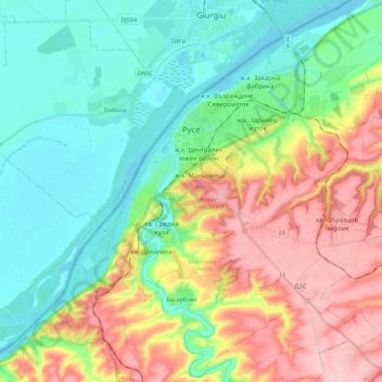
Name: Ruse topographic map, elevation, terrain.
Location: Ruse, Bulgaria (43.74200 25.86198 43.90102 26.08241)
Average elevation: 72 m
Minimum elevation: 12 m
Maximum elevation: 171 m
Make a donation
Gear up for your next adventure:
As an Amazon Associate, this site earns from qualifying purchases at no extra cost to you.
Other topographic maps
Click on a map to view its topography, its elevation and its terrain.