Sandanski topographic map
Click on the map to display elevation.
Sandanski
Sandanski has developed in an amphitheatrical fashion on the outer south-west flanks of Pirin Mountains along the lower reaches of Sandanska Bistritsa River. The town's altitude varies between 240 and 300 meters. Its geographical location between Kresna and Rupel Gorges determines town's mild winter temperatures. Statistically Sandanski has the warmest temperatures in Bulgaria with a total of around 2700 annual sunshine hours.
About this map
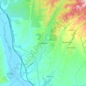
Name: Sandanski topographic map, elevation, terrain.
Location: Sandanski, Blagoevgrad, 2800, Bulgaria (41.52542 23.23864 41.60542 23.31864)
Average elevation: 276 m
Minimum elevation: 97 m
Maximum elevation: 827 m
Other topographic maps
Click on a map to view its topography, its elevation and its terrain.

Bansko
Bansko lies at the foot of the Pirin Mountains, not far from the national park of the same name, in the valley of the Nestos River at an elevation of 925 meters above sea level. It is a ski resort. The city is about 160 km from Sofia and about 220 km from Thessaloniki.
Average elevation: 1,597 m